VISION
BUILD THE IMMERSIVE TOUR OF YOUR ASSET FOR EXPLORING, DESIGNING, TRACKING, OPERATING, MAINTAINING AND TRAINING.
BUILD THE IMMERSIVE TOUR OF YOUR ASSET FOR EXPLORING, DESIGNING, TRACKING, OPERATING, MAINTAINING AND TRAINING.
a. LIDAR – fastest, accurate, and most cost-efficient way of getting topographic data.
b. Aerial Mapping – provides visualization and sub-meter grade accuracy, perfect for areas with few vegetation.
c. GPR – for underground structures; complements geotechnical and geophysics.
d. Bathymetry – data underwater; for hydro-electric projects, bridges, ports, offshore projects.
e. Boundary Survey – delineating project area prior to development.
f. Route Survey – for alignment of power lines, roads, and pipe lines.
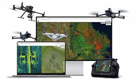
a. Thermal Inspection – crucial for O&M especially for solar, geothermal, energy transmission and distribution.
b. Routine Aerial Mapping – for change detection.
c. Environmental Monitoring – for sustainability and compliance.
d. Terrestrial Laser Scanning – interior scanning of facilities for damage assessment, re-modelling.
e. AI Detection – Asset monitoring, Infrastructure inventory, insurance Survey, Content Management.
f. Drone Inspection – visually check for damages such as cracks and corrosion, e.g. wind turbines, solar panels, telecom towers.